NISAR satellite to offer precise monitoring of Earth’s surface movements

Technology tamfitronics

NISAR satellite to offer precise monitoring of Earth’s surface movements
by Clarence Oxford
Los Angeles CA (SPX) Nov 09, 2024
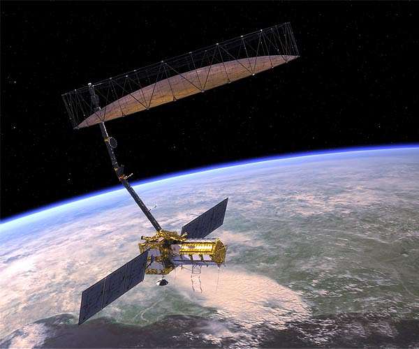
Data from NISAR will improve our understanding of such phenomena as earthquakes, volcanoes, and landslides, as well as damage to infrastructure.
Earth’s surface is in a state of continuous motion, although often unnoticed. Scientists have utilized satellite and ground-based technology to observe movements linked to geological events such as earthquakes, landslides, and volcanic activity. A new initiative by NASA and the Indian Space Research Organisation (ISRO) aims to enhance this knowledge and potentially aid in disaster preparedness and recovery efforts.
The NASA-ISRO Synthetic Aperture Radar (NISAR) mission is set to measure the movement of nearly all land and ice-covered regions on Earth twice within a 12-day period. This frequent data collection will offer researchers a more comprehensive understanding of how Earth’s surface evolves.
“This kind of regular observation allows us to look at how Earth’s surface moves across nearly the entire planet,” said Cathleen Jones, NISAR applications lead at NASA’s Jet Propulsion Laboratory in Southern California.
Combined with data from other satellites and monitoring tools, NISAR’s observations will provide deeper insight into surface movements both horizontally and vertically. This will be essential for studying Earth’s crustal mechanics and identifying areas susceptible to seismic and volcanic activities. The data could also help determine whether infrastructure such as levees is damaged or if a slope is beginning to shift before a landslide occurs.
Detailed Earth Monitoring
Scheduled for launch from India in early 2025, NISAR will detect surface changes with a precision down to fractions of an inch. Besides tracking surface shifts, the satellite will monitor the motion of ice sheets, glaciers, and sea ice, as well as map vegetation changes.
The satellite’s capability comes from its dual radar instruments operating at long wavelengths: an L-band system constructed by JPL and an S-band system built by ISRO. NISAR is the first satellite to carry both, enabling it to collect data continuously, regardless of cloud cover or time of day. The L-band system will be particularly useful for observing ground movement beneath dense vegetation, aiding studies around volcanoes and geological faults obscured by forest cover.
“The NISAR satellite won’t tell us when earthquakes will happen. Instead, it will help us better understand which areas of the world are most susceptible to significant earthquakes,” said Mark Simons, U.S. solid Earth science lead for the mission at Caltech in Pasadena, California.
NISAR’s data will highlight which parts of faults are locked and potentially building up strain, and which move more gradually. In regions with existing monitoring, such as California, researchers can zoom in on specific earthquake-prone zones. In lesser-studied areas, NISAR’s information could identify previously unknown risks. Following an earthquake, its data will help scientists examine fault movements.
Sreejith K M, the ISRO solid Earth science lead for NISAR at the Space Applications Center in Ahmedabad, India, remarked on the importance for India: “The area has produced great magnitude earthquakes in the past, and NISAR will give us unprecedented information on the seismic hazards of the Himalaya.”
Volcano researchers will also benefit from regular surface motion data to spot signs of impending eruptions. Shifting magma often results in surface bulging or subsidence. NISAR’s observations will offer clues as to why and how a volcano changes shape and if that indicates an upcoming eruption.
Infrastructure Analysis
For infrastructure like levees, aqueducts, and dams, NISAR’s long-term data collection will create a baseline of normal conditions. Changes from that baseline could guide resource managers to specific areas needing inspection. “Instead of going out and surveying an entire aqueduct every five years, you can target your surveys to problem areas,” said Jones.
Such monitoring is invaluable after disasters like earthquakes, particularly where liquefaction can affect stability, as seen in California’s Sacramento-San Joaquin River Delta region. “There’s over a thousand miles of levees,” Jones noted. “You’d need an army to go out and look at them all.” NISAR’s space-based perspective would help authorities prioritize inspections efficiently, potentially saving significant resources in post-disaster repair.
Related Links
NISAR
Tectonic Science and News
The content herein, unless otherwise known to be public domain, are Copyright 1995-2024 – Space Media Network. All websites are published in Australia and are solely subject to Australian law and governed by Fair Use principals for news reporting and research purposes. AFP, UPI and IANS news wire stories are copyright Agence France-Presse, United Press International and Indo-Asia News Service. ESA news reports are copyright European Space Agency. All NASA sourced material is public domain. Additional copyrights may apply in whole or part to other bona fide parties. All articles labeled “by Staff Writers” include reports supplied to Space Media Network by industry news wires, PR agencies, corporate press officers and the like. Such articles are individually curated and edited by Space Media Network staff on the basis of the report’s information value to our industry and professional readership. Advertising does not imply endorsement, agreement or approval of any opinions, statements or information provided by Space Media Network on any Web page published or hosted by Space Media Network. General Data Protection Regulation (GDPR) Statement Our advertisers use various cookies and the like to deliver the best ad banner available at one time. All network advertising suppliers have GDPR policies (Legitimate Interest) that conform with EU regulations for data collection. By using our websites you consent to cookie based advertising. If you do not agree with this then you must stop using the websites from May 25, 2018. Privacy Statement. Additional information can be found here at About Us.
Discover more from Tamfis Nigeria Lmited
Subscribe to get the latest posts sent to your email.


 Hot Deals
 Shopfinish
 Shop
Shop Appliances
 Babies & Kids
 Best Selling
 Books
Books Consumer Electronics
 Furniture
 Home & Kitchen
 Jewelry
 Luxury & Beauty
 Shoes
Shoes Training & Certifications
 Wears & Clothings


